
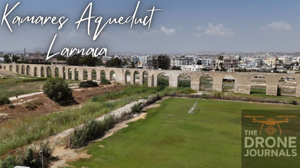
Cyprus is a land rich in history, and few structures capture the ingenuity of the island’s past like the Kamares Aqueduct in Larnaca. Built in the 18th century during Ottoman rule, this impressive aqueduct once supplied fresh water to the city, standing as a testament to human engineering and resilience. While walking beneath its arches is captivating, seeing it from above with a drone provides a perspective that fully reveals its scale, symmetry, and relationship with the surrounding landscape.
The drone footage begins with a wide aerial sweep over the aqueduct and its surroundings. From above, the full length of the structure becomes visible, stretching across fields and low hills. Its series of arches, constructed with precise stonework, forms a rhythmic pattern that draws the eye along the aqueduct’s path. The drone highlights the way this man-made marvel integrates into the natural landscape, blending seamlessly with olive groves, scrublands, and nearby roads.
As the camera moves closer, details of the aqueduct’s construction emerge. The arches cast long shadows across the earth, emphasising the careful geometry of the design. The stonework, weathered yet enduring, reflects centuries of exposure to the elements. From this vantage point, it is easy to appreciate not only the aqueduct’s architectural elegance but also the foresight of the engineers who created a structure capable of transporting water across such challenging terrain.
The surrounding landscape is equally compelling from above. Olive trees, fields, and small clusters of houses provide a textured backdrop, contrasting the straight lines and repeated arches of the aqueduct. The aerial view reveals subtle curves and slight elevation changes that might be difficult to notice from the ground, offering a comprehensive sense of the site’s scale and how it once functioned as a lifeline for Larnaca.
Lighting plays a crucial role in highlighting the aqueduct’s beauty. During sunrise or late afternoon, warm sunlight accentuates the texture of the stone, while shadows elongate beneath each arch, creating a dramatic interplay of light and form. The combination of geometry, light, and surrounding greenery makes the aqueduct visually striking, and from the drone’s perspective, its elegance is fully realised.
For travellers, the Kamares Aqueduct is more than a historical relic; it is a connection to the past, a reminder of the engineering and vision that sustained communities long before modern infrastructure. For drone enthusiasts and photographers, the site offers endless possibilities to capture sweeping panoramas, architectural details, and the interaction between human-made structures and natural terrain.
As the drone ascends for a final panoramic shot, the aqueduct stretches across the landscape like a stone ribbon, anchoring Larnaca’s past to its present. From above, it is easy to see why the Kamares Aqueduct remains one of Cyprus’s most enduring symbols of history, ingenuity, and beauty—a must-visit for anyone exploring the island’s architectural and cultural treasures.
Leave a Reply